 |
| Climatic Regions 1 Chart |
Spectrum Chart - 334 : Climatic Regions 1
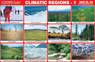
1. Polar Region (North Pole) – The polar
regions of Earth, also known as Earth's frigid zones, are the regions
of Earth surrounding its geographical poles. These regions are
dominated by Earth's polar ice caps, the northern resting on the
Arctic Ocean. There are many settlements in Earth's north polar
region. Countries with claims to Arctic regions are: the United
States(Alaska), Canada, Denmark (Greenland), Norway, Finland, Sweden,
Iceland and Russia.
2. Antarctic Region – The Antarctic
region is a polar region, specifically the region around the Earth's
South Pole. The region covers some 20% of the Southern Hemisphere.
Antarctic region had no indigenous population when first discovered,
and its present inhabitants comprise a few thousand transient
scientific and other personnel working on tours of duty at the
several dozen research stations maintained by various countries.
3. Taiga Region - Taiga region is
characterised by coniferous forests consisting mostly of pines,
spruces and larches. Taiga region is the world's largest land biome
and makes up 29% of the world's forest cover. The taiga region has a
subarctic climate with very large temperature range between seasons,
but the long and cold winter is the dominant feature. The taiga
experiences relatively low precipitation throughout the year.
4. Pampa Region (Low Land Plains) –
Pampas region are fertile South American lowlands, covering more than
750,000 km2, that include the Argentina, most of Uruguay
and the southernmost Brazil. The climate is mild, with precipitation
of 600 to 1,200 mm, more or less evenly distributed through the year,
making the soils appropriate for agriculture. These plains contain
unique wildlife because of the different terrains around it. Some of
this wildlife includes the rhea, the pampas deer, several species of
armadillos, the pampas fox, the white-eared opossum, the elegant
crested tinamou and several other species.
5. Prairie Region – Prairie region are
ecosystems considered part of the temperate grasslands, savannas and
shrublands biome by ecologists, based on similar temperate climates,
moderate rainfall and a composition of grasses, herbs and shrubs,
rather than trees, as the dominant vegetation type. Prairie regions
in North America is usually split into three groups: wet, mesic and
dry. They are generally characterised by tall grass prairie, mixed or
short grass prairie depending on the quality of soil and rainfall.
6. Temperate Region (Steppe) – A steppe
is an eco region, in the montane grasslands and shrublands and
temperate grasslands, savannas and shrublands biomes, characterised
by grassland plains without trees apart from those near rivers and
lakes. Steppes are usually characterised by a semi-arid and
continental climate. Extremes can be recorded in the summer of up to
40 °C and in winter, −40 °C. Besides this huge difference between
summer and winter, the differences between day and night are also
very great.
7. Savannah Grassland Region – Savannah
is a grassland ecosystem characterised by the trees being
sufficiently widely spaced so that the canopy does not close. The
open canopy allows sufficient light to reach the ground to support an
unbroken herbaceous layer consisting primarily of grasses. Savannas
are characterised by seasonal water availability, with the majority
of rainfall confined to one season. Savanna covers approximately 20%
of the Earth's land area.
8. Coniferous Forest - Coniferous forests
are made up mainly of cone-bearing or coniferous trees, such as
spruces, hemlocks, pines and firs. The leaves of these trees are
either small and needle-like or scale-like and most stay green all
year around. Coniferous forests are found mainly in the northern
hemisphere. Coniferous trees thrive where summers are short and cool
and winters long and harsh.
9. West European Type Region - The climate
of Western European type region varies from subtropical and desertic.
Western European region lands are used for many different types of
agriculture, which is caused by the differences in climates and the
different terrain that can be found in each region.
10. Snow Mountain Region (Glacier) - A
glacier is a large body of ice and snow. It forms because the snow in
an area does not all melt in summer. Each winter, more snow is added.
The weight of all the snow creates pressure. This pressure turns the
lower parts of the snow into ice. After this happens for many years,
the glacier will start growing large. It becomes so heavy that
gravity causes the ice to move. Glaciers are the largest sources of
fresh water on Earth.
11. Rain Forest – A rainforest is a
forest that gets a lot of rain. The most notable rainforests are
tropical or sub-tropical. A typical rainforest is the Amazon
rainforest. Forests like this have extraordinary biodiversity. It
covers over half of all plant and animal species live in the
rainforest. Also more than 1/4 of all medicines come from here.
Covering only 6% of the Earth's land area they are still an important
source of oxygen.
12. Himalayan Region – Himalayas are a
mountain range in South Asia, the highest in the world. 15 highest
mountains in the world are in the Himalayas. The main ones are the
Mount Everest, K2, Annapurna and Nanga Parbat. Mount Everest is the
highest mountain on the face of the Earth. Mount Everest is 8,848
meters. Himalayas contain the third-largest deposit of ice and snow
in the world, after Antarctica and the Arctic. The Himalayan range
encompasses about 15,000 glaciers.

No comments:
Post a Comment