 |
| Forms of Lands Chart |
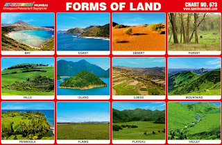
Spectrum Chart - 673 : Forms of Lands
1. Bay – A bay is an area of water. It
is surrounded by land on three sides. A bay is a body of water
connected to an ocean or lake, formed by an indentation of the
shoreline. The land surrounding a bay can often block waves and
reduce the strength of winds. Thus bays were significant in the
history of human settlement because they could provide a safe place
for fishing.
2. Coast – A coast or a seashore is the
area where land meets the sea or ocean. The coast also means the land
next to the sea, which can also be called the shore, or sea-shore.
However, coast is not used to describe where rivers or lakes meet the
land - it is only used to describe the sea meeting the land. Coasts,
especially those with beaches and warm water, attract tourists.
Coasts offer recreational activities such as swimming, fishing,
surfing, boating and sunbathing.
3. Desert – A desert is a barren area of
land where little precipitation occurs and consequently living
conditions are hostile for plant and animal life. Hot deserts are
mostly in the subtropics. They can be covered by sand, rock, salt
lakes, stony hills and even mountains. The largest hot desert in the
world is the Sahara in North Africa.
4. Forest – A forest is a large area of
land covered with trees or other woody vegetation. Forests are very
important and grow in many places around the world. They are an
ecosystem which includes many plants and animals. Forests account for
75% of the gross primary productivity of the Earth's biosphere and
contain 80% of the Earth's plant biomass.
5. Hills – A hill is a land form that is
higher than the surrounding terrain and that is smaller than a
mountain. Hill is a highland of much lower elevation than a mountain.
Normally it is not as steep as a mountain. The surface of a hill is
much more stable than that of a dune.
6. Island – An island is a piece of
ground that is surrounded by a body of water such as a lake, river or
sea. Water is all around an island. There are two main types of
islands: continental islands and oceanic islands. The largest island
in the world is Greenland.
7. Loess - Loess is a clastic,
predominantly silt-sized sediment that is formed by the accumulation
of wind-blown dust. It covers about 10% of the Earth's surface. Loess
is homogeneous, porous, friable, pale yellow or buff, slightly
coherent, typically non-stratified and often calcareous. Loess grains
are angular with little polishing or rounding and composed of
crystals of quartz, feldspar, mica and other minerals.
8. Mountains – A mountain is a large
land form that stretches above the surrounding land in a limited area,
usually in the form of a peak. A mountain is generally steeper than a
hill. Mountains are formed through tectonic forces or volcanism.
Mountains erode slowly through the action of rivers, weather
conditions and glaciers. A few mountains are isolated summits, but
most occur in huge mountain ranges. The highest mountain on Earth is
Mount Everest in the Himalayas.
9. Peninsula – A peninsula is a piece of
land that is bordered by water on three sides but connected to
mainland. Many countries are found on peninsulas and may either take
up part of a peninsula or all of it, such as India. The Arabian
Peninsula is the largest peninsula in the world with an area of
3,237,500 square kilometres.
10. Plains – A plain is a flat &
large area of land with no hills or mountains. Plains occur as
lowlands and at the bottoms of valleys but also on plateaus or
uplands at high elevations. Plains in many areas are important for
agriculture because where the soils were deposited as sediments they
may be deep and fertile and the flatness facilitates mechanisation of
crop production.
11. Plateau – A plateau is an area
of highland, usually consisting of relatively flat terrain that is
raised significantly above the surrounding area, often with one or
more sides with steep slopes. Plateaus can be formed by a number of
processes, including upwelling of volcanic magma, extrusion of lava
and erosion by water and glaciers. The largest and highest plateau in
the world is the Tibetan Plateau.
12. Valley – A valley is a type of land
formation. A valley is a lower part in the land, between two higher
parts which might be hills or mountains. A valley is made deeper by a
stream of water or a river as it flows from the high land to the
lower land, and into a lake or sea. Some valleys are made by glaciers
which are slow-moving rivers of ice. Many of the people of the world
live in valleys because there is often a river or stream in a valley
for fresh water and there is often good soil in a valley to grow
crops.

No comments:
Post a Comment